Another anti-tank ditch exercise
Posted: 7 December 2012 21:53
Following on from the anti-tank ditch I wrote about last month, some documentary evidence combined with a trip into a soggy landscape locates speculative evidence of a similar training exercise.
This particular exercise was conducted in 1942 by the Royal Canadian Engineers, although not on the same RE training ground as previously described.
The documents describe the exercise which took place near a reservoir with a stream flowing into it:
1. To prepare a combined Infantry and Anti-Tank obstacle.
2. To take a defensive position.A dragline has been improving the stream bed into an anti-tank obstacle. (A 'V' ditch 25 feet across shoulders.) Unfortunately the drag has broken down only 40 yards North of the reservoir.... Wire has been placed inside the ditch up to where the drag has broken down. The drag is being taken away as it cannot be repaired where it is. Your section has been ordered to complete this obstacle as soon as possible after receipt of the order and to occupy a defensive position for 24 hours.
The OC says there are some Anti-Tank Mines Mk.IV that have been carried by the company for some time and that you may have them. The foot bridge by the lake will not be disturbed. It may be assumed that the obstacle continues on the south of the lake.
A dragline is an earth-moving machine employing a free-swinging heavy bucket that cuts into the earth by virtue of its weight; it is then dragged towards the excavator by cable, thus removing spoil.
The exercise was divided between the three sections of the Field Company as follows:
10th February 1942 - No.1 Section: 08:15 - 12:00
10th February 1942 - No.2 Section: 13:15 - 17:00
11th February 1942 - No.3 Section: 08:15 - 12:00
From my reading of the full orders, it appears that the object was to complete the anti-tank defence between the 'ditch' and the reservoir, mines being made available to do this. Areas of digging could be indicated by laying tapes, except in the case of mines. All mines, wire and tape were to be collected up after the exercise. I could only assume that the real emphasis of the exercise was placed on the use of mines and barbed wire.
I use inverted commas regarding the 'ditch', because both it and the dragline do not actually have need to have been real - they might have been purely mentioned for the sake of realism in the exercise scenario. If digging could be represented by marking out with tape, then there was every chance that the ditch was fictional too.
However, the daily entries in the war diary add the following information:
10th February: Warmer - snow well gone. Section 1 and Section 2 were given a half day exercise on the training mines - which involved the use of mines - placing of wire - improving obstacles and siting of Anti-Tank Rifle and Bren Guns.11th February: Clear but cool - the ground did not thaw appreciably. Section 3 spent the morning on the use of mines and constructing an anti-tank ditch.
From this we have confirmation about the focus on mines and wire, and the infantry positions probably only being marked out - 'sited' as opposed to actually being dug in the frozen ground. The tantalising part however, is the construction of an anti-tank ditch by No.3 Section!
I therefore decided to take a trip out to the grid reference given in the diary and see if any landscape evidence still remained. Having parked up, I faced a half-mile walk across heathland and forest to reach the site.
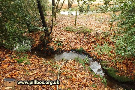
The recent heavy rain made things worse, as most of the walk was conducted in ankle-deep mud followed by calf-deep waterlogged ground.
Knowing that I was looking for a stream that had possibly been excavated didn't prepare me for deep inundation on the banks; the water nearly spilled over the top of my wellies in places.
The nature of the stream at this point is seen in the photo at right; narrow, shallow and very bendy.
The water is flowing down towards the reservoir mentioned in the war diary, hence the scouring and deposition of material causing the meanders.
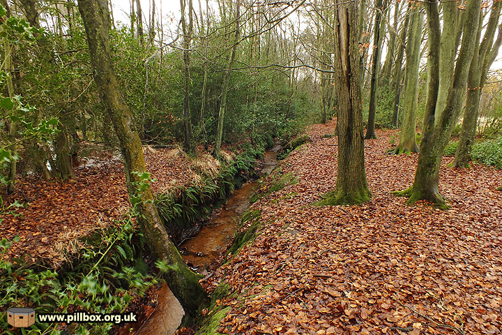
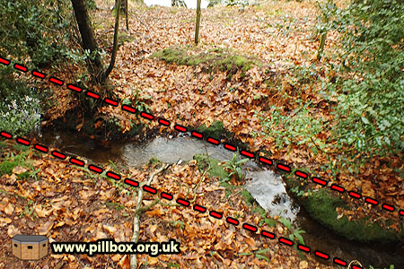
Following the stream as it wended its way through some woodland I found myself standing at a point where the meanders ceased and a low waterfall marked where the stream suddenly straightened out, as shown in the photo below:
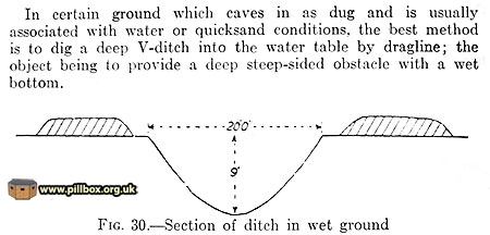
However, we have a slight problem in that the exercise orders describe a 'V' ditch 25ft (nearly 8m) wide across the shoulders.
The 1940 Military Training Pamphlet regarding obstacles provides the illustration at right:
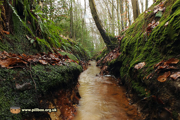
The straight section of stream is only 7 feet across the shoulders and the depth ranges from about 5 - 8 feet deep - it matches neither the manual nor the textual description.
But is the 25ft span stated in the documents simply setting the scene? If the ditch really was 25ft across, why bother to state this in the exercise orders? Would it not be obvious it was an anti-tank ditch? I think the troops are being asked to imagine that it's a V-shaped anti-tank ditch - or at least that the ditch is wider than it actually is. The orders do state they are to assume the obstacle continues the other side of the reservoir.
But the diary states that No.3 Section did construct an anti-tank ditch. Is this 30m section of stream it - perhaps turning an imaginary anti-tank ditch into a real one? The photo below shows the nature of the ditch; note how straight and comparatively 'neat' it is.
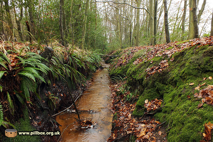
Moving down into the stream in the photo below, we can see that the right bank (the 'home' side in the exercise) is higher than the left. The manuals don't especially advocate making the home bank higher, but it also may explain why there's a complete absence of spoil heaps - was the spoil carefully shovelled onto the home bank? The home bank is uphill, perhaps explaining its increased height, but the height of the two banks switches in a few places along the whole length of the stream that I followed.
Digging a fresh ditch, an excavator would probably simply reverse, digging the ground between its caterpillar tracks as it went. However, there's no easy access to allow a dragline to straddle the stream - there might be a risk of the banks collapsing anyway - so did the dragline work from one bank and dump spoil on the other for men to shovel? This might explain why the ditch sides are not as perfect as other examples in Sussex.
As you'll have seen above, I can only suggest that the work was actually carried out by a dragline, as mentioned in the war diary. The bed and lower bank are bedrock and would require mechanical excavation. Don't forget that it's February, there's a lot of snow meltwater and the men are unlikely to stand in freezing water hacking away at rock with hand tools for four hours.
Judging by indents in both banks, it seems that about four or five meanders have been cut out such as indicated in the photo at right of the untouched stretch of the stream.
Does it matter that the ditch is narrower than the manual specifies? No, I don't think it does - I think that the principle was sufficiently demonstrated by creating a miniature anti-tank ditch, just as the principle of siting weapons was adequately put across by simply marking positions instead of digging them.
The army would also be hampered by the fact the ditch was an existing stream and a means of drainage. I suspect that the 40-yard gap (it's actually more like 60 yards) between the ditch and reservoir was to preserve the stream and a pair of tributary streams that flow into it at that point. The reservoir is not on the 1899 map, so would have been relatively new, and there was also an agreement between the army and the landowner that damage to the area would be minimised.
So to sum up: I believe this is a stretch of stream modified to become an anti-tank ditch. This is based on it being a comparatively straight section in an otherwise gently meandering water course at a location documented as having been the scene of such activity. The stream might have been dredged prior to, or perhaps as part of, a training exercise on 10-11 February 1942.
As with the previous training exercise anti-tank ditch, I could easily stand in it and not be able to identify it as such, for several reasons. Firstly, both ditches are just 30m long, and their locations make no tactical sense - as they shouldn't, being the result of training exercises. Both are modifications of existing landscape features, and, after 70 years, their form is disappearing back into obscurity.
It wasn't until documents from two different armies in two different years were located in the archives two months apart that these features have suddenly been brought back to the fore.
The surprising thing is that anti-tank ditches in Britain have always been associated with the invasion scare of 1940-41 and yet these two ditches fall either side of that period!
- Pete

Email:
Blog Latest
Bishopstone reveals its pillbox secrets
18 October 2021
Pillbox or Observation Post?
10 June 2020
Uncovering the hidden secrets of a pillbox
8 June 2019
Review of 2018
31 December 2018

Wartime Christmas in East Sussex (2)
24 December 2018
Jargon-buster
Anti-tank ditch
Ditch designed to hinder movement of tanks and AFVs. Ditches could be entirely artificial or existing ditches or natural features such as rivers, might be dredged, shaped and revetted to improve their effectiveness.
War diary
A record of events kept by all units from the point of mobilisation. A diary's contents vary enormously from unit to unit; some give detailed entries by the hour on a daily basis while others merely summarise events on a weekly/monthly basis.
This site is copyright © Peter Hibbs 2006 - 2024. All rights reserved.
Hibbs, Peter Another anti-tank ditch exercise (2024) Available at: http://pillbox.org.uk/blog/216714/ Accessed: 27 July 2024
The information on this website is intended solely to describe the ongoing research activity of The Defence of East Sussex Project; it is not comprehensive or properly presented. It is therefore NOT suitable as a basis for producing derivative works or surveys!