Bomb craters (6) - mystery bunker identified!
Posted: 26 July 2012 19:32
Several years ago I stumbled across an unusual underground bunker on a steep hillside on the Downs near Eastbourne. The structure remained a mystery until I began writing this series of blog entries about bomb craters.
By sheer coincidence, not only have I uncovered an as yet unrecorded bomb crater, but have also positively identified the structure that has puzzled historians and archaeologists for decades!

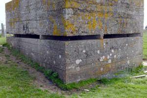
The bunker today is sealed; all that is visible is a brick/concrete entry hatch raised above ground (Right). This has been capped with concrete for safety, and this was how I found it - it also means that I haven't actually been inside.
However, I do know of two people who did view the interior and I would like to thank Stewart Angell and David Hart for their assistance and kind permission to use their photographs.
Stewart, (author of The Secret Sussex Resistance), measured the interior in the 1980's and kindly supplied me with a copy of his survey data.
Because there is no emergency exit, Stewart ruled out a Home Guard Auxiliary Unit connection, but was otherwise as stumped as everyone else I've encountered who knows of this structure.
Other suggestions from various sources have ranged from a 'secret' military battle headquarters to an Emergency Water Supply (EWS) tank for firefighting purposes, or perhaps an emergency supply of drinking water in case the mains were ruptured in an air raid. For what it's worth, my money was on the latter - until I found some interesting documents!

Mystery bunker
The structure is basically a rectangular concrete chamber with its roof just below ground level.
A single hatch in the roof at one corner provides access.
A metal ladder fixed into the wall disappears down into the echoey gloom.
The photo at right shows the metal hatch interface - it looks from the design as though the hatch was meant to be air-tight.

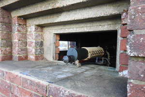
At right is an interior view, looking into a corner.
The presence of rubbish, backfill and vandalism were more than enough reason for the hatch to be sealed to prevent access and further damage.
I've been told that the tank has also been backfilled with soil as part of the sealing up process.
The internal dimensions are roughly as follows: 3.5m long, 2.3m wide and 2m deep.
Mystery solved at last!
I'll put you out of your misery now - the bomb report I located at TNA gives a matching grid reference and reports that: "Bomb fell on face of hill and 20ft from underground concrete reserve water tank."
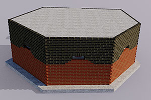
Using Stewart's survey plan and with reference to David's photographs, I created a 3D model of the water tank. The graphic below also includes structural detail gleaned from another document I found later on.

The bomb report
The action took place in early 1944; two twin-engined fighter-bombers (identified as such only by speed and sound) flew in over Eastbourne at 15,000ft. The air raid sirens had already sounded three minutes before.
The track of the first aircraft was lost, but it subsequently dropped a single bomb some miles away, bringing down some power lines and inflicting light injuries on a woman, who was hit by flying glass.
The second aircraft circled over the town a few times (presumably trying to locate it in the black-out) and then dropped two bombs, one hitting the hillside where our tank is, the other falling harmlessly onto a golf course.
Further detail of the bomb in question is as follows:
Bomb fell on face of hill and 20ft from underground concrete reserve water tank, capacity 8,000 gallons. Damage: Water tank fractured and all water lost.

It was this that made the connection with the mystery underground bunker; all I had to do was head straight for the tank and I should be presented with a nice bomb crater 7m away... However, I know from experience that nothing is ever that easy, so you can imagine my surprise when, arriving at the scene, the crater was clearly still there!
The plan at right shows the relationship between the tank and the crater.
The only problem is that the local kids have built a "camp" right in the crater, making it very hard to photograph and measure.
The photo below shows the crater; ringed in red is what appears to be the extent of the 'dish' when you're viewing it on the ground. The red shading heading up the slope is the crater extent going by the report's measurement of 29ft. The tank is buried at the top of the slope, indicated by the arrow.

The photo below shows the estimated extent of the tank (by measurement) marked out in white tape on the surface; the crater is over the lip of the slope, indicated by the 'wigwam' of branches at top centre:

Tank capacity
After a couple of visits to the site to get data, I still had numerous questions, particularly about the size of the tank. The given capacity was 8,000 gallons, but taking the known dimensions, I was getting figures of less than half that. I'm always wary of errors in documents; more so in this case as the report stated that Eastbourne was in Kent!

Another visit revealed what I thought might be a second tank, judging by a section of masonry hatch shaft (photo right) I located further down the slope. A second identical tank would bring the total amount to nearly 8,000 gallons.
However, I now believe this was either an inspection hatch for some sort of pumping equipment or supply stop-cock, as a further discovery at TNA proves there was only one tank - and of the 3,600 gallon capacity I had previously calculated from the dimensions!
A full incident report
The document I had been relying on so far was an initial report (known as a Form B.C.4), only giving the basic details of events. A stroke of luck when browsing the TNA online catalogue last Saturday morning had me making a snap decision (I didn't even finish my cup of coffee) to dash up to London and look at what I hoped would be a more detailed report of the incident.
I found the detailed file had everything I wanted - a report, full construction specification of the concrete and its reinforcing rods, measurements and a fantastic plan and elevation of the crater, the tank and the damage caused!
Reading through the correspondence, I found a duplicate copy of the B.C.4 and a memo calling for more information:
It is reported on B.C.4 that this bomb fell 20ft from underground concrete reserve water tank, capacity 8,000 gallons.It is stated that the tank was fractured and all water lost.
A report is required covering the incident, and giving particular attention to any evidence of earthshock. (My emphasis)
Also plan and section showing the construction of the tank and the damage caused.
Every endeavour should be made to obtain fragments in order to assess the size of the bomb.
Why have I highlighted the line mentioning earthshock? In order to study local history, you frequently need to understand what was happening on a wider scale, and the timing of this incident is of interest.
At this time, the first use of Barnes Wallis' Tallboy bomb was only a matter of weeks away. The bomb was designed to penetrate the ground beside a target and explode below it, causing a small 'earthquake' and creating a camouflet cavern to undermine the foundations.
Perhaps the powers that be were fearful that the Germans were suddenly deploying their own earthshock bombs and that maybe the Tallboy's secrecy had been compromised.
Allied intelligence, of course, also knew about the forthcoming V-weapon attacks and, in early 1944, anything out of the ordinary that the Germans were seemingly doing was bound to draw attention.
However, it seems that the damage to the water tank was caused by a standard 250kg bomb and was nothing unusual, following the detailed inspection of the scene, carried out a few weeks after the incident.
Crater section
The documentary and landscape evidence for this incident are as yet unprecedented in my research to date. A Form B.C.4 and full report were filed and archived on the documentary side of things; as far as the landscape goes, the crater and the damaged structure still survive and this combination is currently unrivalled.
The other first that the full report delivers is a properly surveyed and drawn section of a crater; most reports have no crater details aside from dimensions - in a few cases you get a rough pencil sketch but nothing to rival the ink plan and elevation in this particular file.
This exciting fact provides a fantastic opportunity to compare my section surveyed in 2012 with that measured when the crater was fresh in 1944. The graphic below shows my reconstruction of part of the 1944 section; the red line is my 2012 section overlaid to scale. Of note is how the upper part of the slope appears to have slumped onto the crater floor. My survey also reveals a deeper (left hand side) section; this may be because my section is probably not along exactly the same line as was measured in 1944 and it's quite possible that the kids that built their camp in the crater have been moving earth around. Whatever the discrepancy, it's still important data!

Damage to the water tank
The graphic above hints at the cracking of walls and the buckling of the structure at the end closest to the bomb. The composition of the 8-inch concrete walls was described as being of good quality; the walls and floor had steel reinforcing rods, while the roof slabs were bolstered by a series of lateral RSJs.
Below is a cutaway showing the reinforcement and the extent of the fracturing of the concrete as surveyed in 1944. Note the crack in the floor; the roof suffered a similar crack that displaced one of the slabs by 5cm. The end wall was bulged in at the centre by up to 15cm as a result of the shockwave from the explosion.


The photo at right is the internal view seen above and shows evidence of the cracks in the wall - I zoomed in on the full-size photo and traced the cracks I could make out.
The corner is the one diagonally opposite to the hatch, i.e. on the right is the end wall we see cracked in the graphic above and looking straight towards the crater.
The roof crack is described as "transverse...with oblique branch to crater end" and this seemingly matches up in the photo.
The rear wall cracks, however, do not appear as prominent as they do in the 1944 survey and their pattern and location doesn't fully match the diagrams; perhaps an attempt was made to seal the cracks with a view to refilling the tank after the war? This point is just pure speculation however.
One thing we no longer need to speculate on is the real purpose of the tank...
So what was this tank for?
The report clears up the mystery once and for all as to what the tank was really used for.
Remember the possible 'secret' military underground battle HQ/Auxiliary Unit hideout/ water supply theories mentioned above?
I can now reveal that this tank predates the war and was used for a purpose no more secret or sinister than to water the greens on the nearby golf course! This episode demonstrates that an unexplained feature doesn't always have to be military-related and/or secret in nature.
When faced with an unknown quantity such as this and all other possibilities (agricultural, industrial etc uses) have been ruled out, then military/wartime use is the default explanation. I completely understand this way of thinking and indulge in it myself all the time, but I think it also offers the historian/archaeologist some sort of comfort in that speculating that a structure is military carries within itself the reason why no better explanation is forthcoming.
The magic formula is thus: military structure = secret. 'Secret' conveniently explains why nothing is known and therefore puts the researcher in a place from which contradiction of their theory is difficult - until people like me come along with solid documentary evidence!
In all honesty, I speculated a military/wartime use for this tank myself until I saw the documents. It doesn't matter to me that my initial thoughts were wrong; the point is that I've positively identified the actual use of the structure.
What's even better is that we now know the full story and have the additional (and previously overlooked) landscape evidence of a bomb crater!
- Pete

Email:
Blog Latest
Bishopstone reveals its pillbox secrets
18 October 2021
Pillbox or Observation Post?
10 June 2020
Uncovering the hidden secrets of a pillbox
8 June 2019
Review of 2018
31 December 2018

Wartime Christmas in East Sussex (2)
24 December 2018
Jargon-buster
TNA
The National Archives (formerly The Public Records Office or PRO).
This site is copyright © Peter Hibbs 2006 - 2026. All rights reserved.
Hibbs, Peter Bomb craters (6) - mystery bunker identified! (2026) Available at: http://pillbox.org.uk/blog/216707/ Accessed: 11 July 2026
The information on this website is intended solely to describe the ongoing research activity of The Defence of East Sussex Project; it is not comprehensive or properly presented. It is therefore NOT suitable as a basis for producing derivative works or surveys!