Pillbox camouflage revealed
Posted: 22 April 2012 11:21
The pillbox on Frant Green is well known and much photographed. New documentary research reveals a lot about this and other long-forgotten GHQ Line pillboxes - including their camouflage schemes.

I first visited this Type 24 pillbox back in 2008; it is listed in Concrete Evidence and several archaeological surveys, but until last week I had no real thoughts about it, aside from my previous comments about the roadblock it covered.
The difference now is that the finding of a fascinating document in The National Archives (TNA) on my latest visit to Kew has opened up a whole new section of stop line defences.
The document listed 22 pillboxes, only two of which have previously been listed, so to be able to get out and find some missing defence works is something special.
A quick foray into the northern sector of the East Sussex Divisional Area has uncovered some of these unrecorded defence works.
A wonderful addition to the information is a description of the camouflage scheme for each pillbox and some information about communications.
So whereas today we see a brick-shuttered pillbox on Frant Green, in 1940 it was disguised as a wooden hut and assigned the serial number R9.


Another pillbox at Frant was also disguised as an everyday structure.
The photo at right shows the Victoria Well to the north (indicated in the photo above). The document lists at or about this location, a pillbox disguised as a well shelter overlooking a roadblock.
The arrow indicates the roadblock location, but where was the pillbox? Nothing remains now, but I'm wondering if it was actually inside the well shelter, assuming the well wasn't still in use in 1940.
If not, then perhaps the pillbox and its camouflage were off to one side, although whether the average German invader would have been suspicious of two such shelters close together is open to question.
A shallow depression is visible in the ground to the north of the shelter, but a hazy postwar aerial photograph shows a large tree here.
Either way, the pillbox would have been quite close and I'm surprised that what would have been a prominent postwar landmark like its neighbour down the road doesn't seem to be mentioned in any of the sources I've seen.
If anyone can set me straight on all this, I'd love to hear from you!
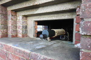
I mentioned communications; moving along the stop line I located another Type 24 by a road, Pillbox no. R3, pictured below.


R3 guarded a road junction with a solitary roadblock of two pimples, eight buoys and eight cylinders. There was no surviving evidence of this block, or of Pillbox R2 that once stood in support on the opposite side of the road.
What is interesting about this position is that it was supported by an observation post (OP) established in a cottage 1,000 yards down the road. The occupants would use a field telephone to warn Pillbox R3 of the advance of any German column up the road. The cottage is still there.
The OP had stores of one telephone and one mile of cable but R3 had two telephones and one radio. One of these telephones was obviously connected to the OP and the other possibly to Pillbox R2. Military HQ could contact R3 via radio. The radio appears not to have been in the pillbox, but "under cover" with a remote control in the pillbox itself. Two signallers, two telephonists and one lineman were needed to run the communications of this defensive position.
I could see no evidence of any wires in R3, but it's fantastic just to know that there was a system of telecommunications in operation with some of the pillboxes on this stop line. The signals equipment for the whole 22 pillbox layout required: 15 telephones, 8 radios, 10 miles of telephone cable, 6 tins of insulating tape and 6 pairs of pliers!
Pillbox R3 was camouflaged with natural foliage, while R2 was somehow disguised with wooden poles.

My next stop was by a defended locality comprising three roadblocks and two pillboxes.
Both pillboxes appear never to have been recorded before, which is quite surprising given their visibility in the landscape.
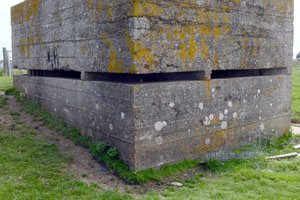
The first is a shell-proof Type 24 situated in a hedge line and able to cover one of the roadblocks.
It seems to have some sort of metal cowelling above the embrasures; the documents indicate that this particular pillbox was camouflaged as a haystack so these fixtures might have kept the hay out of the loopholes.

The next in the line is also a shell-proof Type 24, which to me suggests they were of perhaps a slightly later period of construction, as the other surviving pillboxes in this sector are all of the thin-walled variety.
This one stands atop a hill and can cover all three roadblocks, two of which are on bridges; it was camouflaged as a shed.
You can't appreciate the siting of this one until you've stood at each of the roadblocks locations and seen how the embrasures can cover each.
Unfortunately I couldn't gain access to either of these pillboxes on the day, as time was short; I hope to trace the landowners and explore these on a future visit.

After a few gaps in the line (either by postwar removal or my not having access to private land), the final stop of the day was at Pillbox R6 (left).
I wasn't expecting to locate this one; my interpretation of the Cassini grid reference put it in an unlikely position, but pulling up randomly at the roadside, I found myself staring at an embrasure through my passenger window.
This is the sort of pillbox that only locals will know about due to the vegetation (which, incidently, was its wartime camouflage) despite it being right on the road verge.
A profitable day; of the ten sites I visited I found five pillboxes (three unrecorded), three probably demolished and two probably demolished but possibly hiding in the corner of private land. The exciting thing is that all of this is filling in gaps in the archaeological record and tying together known sites and features such as roadblocks from my database.
The ten sites visited represent less than half the locations listed in the documents; I still have 12 more pillboxes to try and find.
I'm looking for four camouflaged with foliage, one with no camouflage, two barns, a farm building, a lodge, a garage, another haystack and a pigsty...
- Pete

Email:
Blog Latest
Bishopstone reveals its pillbox secrets
18 October 2021
Pillbox or Observation Post?
10 June 2020
Uncovering the hidden secrets of a pillbox
8 June 2019
Review of 2018
31 December 2018
Wartime Christmas in East Sussex (2)
24 December 2018
Jargon-buster
Buoys
Small concrete roadblock obstacle comprising a truncated cone with domed base. A hollow shaft down the centre allowed the buoy to be manhandled using a crowbar. Buoys were deemed of little value by 1941 and cylinders seen as a better solution.
Cassini Grid
Cassini Grid was the map reference system in use on British military maps from 1919 until the introduction of the National Grid Reference system still used today on Ordnance Survey maps. The two systems are not related, and so wartime Cassini references need to be converted to modern National Grid. More information can be found on the maps page.
Cylinders
Reinforced concrete cylindrical obstacles with a shaft down the centre in which could be inserted a crowbar for manhandling, or a picket for barbed wire. Cylinders were 90cm high and 60cm wide and deployed in groups of three as a more effective alternative for buoys.
Defended locality
An area defended by a force (e.g. a platoon) occupying a series of defence works, normally within a barbed wire perimeter. Localities were designed for all-round defence and usually fitted in with a coordinated scheme of neighbouring localities.
Embrasure
A loophole or slit that permits observation and/or weapons to be fired through a wall or similar solid construction.
GHQ Line
A series of arterial stop lines designed to prevent German forces advancing on London and the industrial Midlands.
Loophole
Embrasure
Pillbox
Generic term for a hardened field defensive structure usually constructed from concrete and/or masonry. Pillboxes were built in numerous types and variants depending on location and role.

Pimples
Small anti-tank block in the form of a truncated pyramid. Pimples were used to extend anti-tank obstacles and roadblocks and were intended for use on soft ground.
Stop line
A physical continuous anti-tank barrier, normally a river and/or railway line, often defended by pillboxes. Stop line crossings (roads, railways and bridges) were to be made impassable.
TNA
The National Archives (formerly The Public Records Office or PRO).
Type 24 pillbox
A six-sided (but not a regular hexagon) pillbox. The Type 24 is the most frequently seen pillbox in East Sussex, mostly along stop lines. It can be found in thin wall (30cm) or thick wall (1m) variants.
This site is copyright © Peter Hibbs 2006 - 2026. All rights reserved.
Hibbs, Peter Pillbox camouflage revealed (2026) Available at: http://pillbox.org.uk/blog/216695/ Accessed: 24 June 2026
The information on this website is intended solely to describe the ongoing research activity of The Defence of East Sussex Project; it is not comprehensive or properly presented. It is therefore NOT suitable as a basis for producing derivative works or surveys!