Flying Bombs over East Sussex
Posted: 29 July 2011 11:56
On the night of 12th-13th June 1944 - barely one week after the Allied invasion of France - the Germans unleashed the first of their Vengeance Weapons in the shape of the V1 flying bomb.
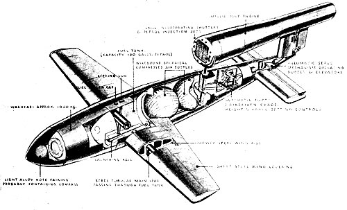
This weapon had already been code-named Diver by the Allies, who had been gathering intelligence under Operation Crossbow from 1943, but the war diaries of the period often refer to them as a Pilotless Aircraft (PAC) or as a Fly. Doodlebug appears to have been a civilian name for the V1, as this term does not crop up in military documents.
The pulse-jet emitted the characteristic droning noise that warned of the approach of the weapon; its constant speed, constant course and constant altitude throughout its normal flight made it easier to intercept. When the fuel supply ran out the bomb began its terminal dive with a ton of high explosive in its warhead.
Various forms of defence were erected; anti-aircraft guns, barrage balloons and interception by fighter aircraft all played their part in defeating the V1 menace.
The attack started with the V1s being dispatched from launch sites in northern France along fixed trajectories towards London, the primary target of the campaign. The bulk of V1s passed over Kent, but East Sussex saw its share of the action; the area around Rye was the busiest, but the western limit of the concentrated Diver gun defences was at Cuckmere Haven.
Strategic overview
The Kent and Sussex coastal areas had already been bolstered with additional anti-aircraft guns as part of the build-up of troop concentrations prior to D-Day and it is to the war diaries of the gunners that we turn to, to get an idea of how East Sussex played a part in the Battle of the V1.
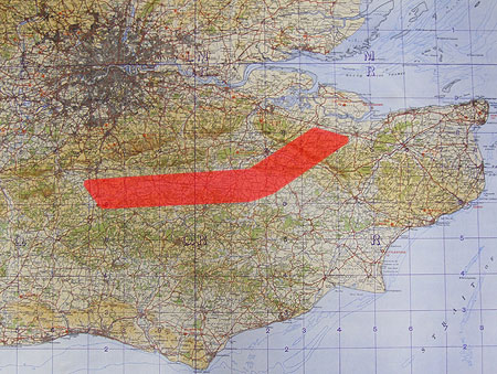
The oiginal anti-Diver defences comprised the Kentish Gun Belt of heavy anti-aircraft guns (HAA) in the north of that county, (shown at right) while the existing light anti-aircraft (LAA) guns at Vulnerable Points (such as radar stations, airfields and coastal towns subject to 'Tip and Run' raids), remained in place to enage any targets that came their way.
A balloon barrage was established on the North Downs, but the first line of defence were fighter aircraft who could engage flying bombs over the Channel and up as far as the Kentish Gun Belt, whereupon the gunners took over.
You don't have to get too deep into the documents to get an idea of the complexity of the operation; as the attacks stepped up, more and more guns arrived in East Sussex, especially after the 'Move to the Coast' in July.
Moving the guns to the coast allowed them to fire out to sea, with fighters operating in front and behind the guns.
The mass exodus of guns from the Kentish Gun Belt and other areas saw local roads in Kent and Sussex jammed with guns, gun tractors and the heavy equipment required to build stable platforms for heavy AA guns such as the 3.7-inch.
The location statement for just one LAA Regiment with 40mm Bofors guns between Beachy Head and Hastings, along with several Squadrons of the RAF Regiment (with 20mm guns) attached reveals a total of 88 gun positions! This document only records the situation at that moment in time, though - the guns were constantly being moved and relocated as no-fire zones were established to protect coastal towns and provide safe passage over the coast for friendly aircraft.
The Allied advance in France drove the V1 attack ever eastwards as the western launch sites were overrun, and so the guns moved to follow suit. This is all documented, but the task of entering all this in the Concrete Evidence database is rather daunting!
The files are also daunting - the frantic activity generated a lot of paperwork as rules of engagement were revised and techinques developed in the light of experience. My progress through these files has speeded up though, as I know that most of the policy documents are duplicates of those I've already copied, leaving me to concentrate on the war diary pages, location statements and engagement reports.
Flying Bomb Trajectories
One interesting document, did, however, provide some of the generic flight paths of V1s over East Sussex. Using this, I managed to plot the paths onto Google Earth, as seen below.
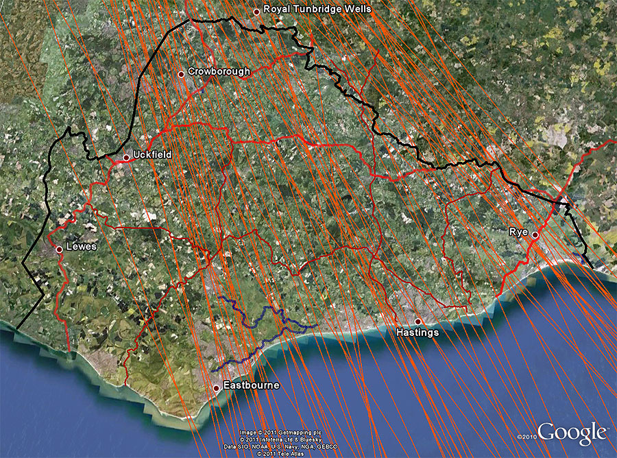
Now, it should be noted that I don't claim these tracks to be especially accurate, particularly as they were based on a small-scale regional plan that may not have been accurate in the first place. Flying bombs were also subject to cross-winds, mechanical defects and interference from the defences all of which could cause deviation from the course. V1s apparently could also yaw to port during the terminal dive. The Luftwaffe also began air-launching flying bombs as the static ramps were captured by the advancing Allies.
Something else I did was to plot V1 crash sites in East Sussex using a 1945 plan printed in the local paper, entitled Where the Flying Bombs Came Down.
Again, the inaccuracy of plotting these needs to be borne in mind, particularly given the scale of the plan and the fact that it's not an official document.
It does, however, give me some tempting insights as to why my grandmother had strong memories of flying bombs.
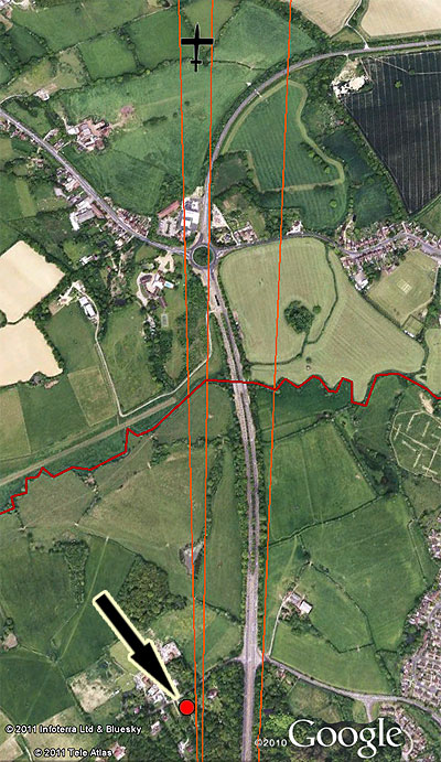
The graphic at right shows three V1 flight paths from my Google Earth plots. The bungalow my Gran was living in from 1940 is indicated at the bottom - it appears (bearing in mind the data inaccuracy) that she was living directly underneath these flightpaths!
I interviewed my Gran about her wartime memories in 1990 and the following account of her mother and my father's close encounter is of particular interest:
When Granny Wood (My Great-grandmother) was living up my way and I had to go out to work and, one of these doodlebugs came over, went right over the house, right over the front and we heard it cut out and Granny pushed Alan (My father) on the floor, by the settee in the front room, ha! ha! and then the thing just exploded out quite a way off from us, further than we thought, luckily.
Now look at the graphic and note the V1 silhouette I plotted as a crash site; could it be the one referenced above?
The fact that it "went right over the house" suggests that the flightpaths are certainly in the right area - more research needed!
- Pete

Email:
Blog Latest
Bishopstone reveals its pillbox secrets
18 October 2021
Pillbox or Observation Post?
10 June 2020
Uncovering the hidden secrets of a pillbox
8 June 2019
Review of 2018
31 December 2018

Wartime Christmas in East Sussex (2)
24 December 2018
Jargon-buster
War diary
A record of events kept by all units from the point of mobilisation. A diary's contents vary enormously from unit to unit; some give detailed entries by the hour on a daily basis while others merely summarise events on a weekly/monthly basis.
This site is copyright © Peter Hibbs 2006 - 2024. All rights reserved.
Hibbs, Peter Flying Bombs over East Sussex (2024) Available at: http://pillbox.org.uk/blog/216685/ Accessed: 27 July 2024
The information on this website is intended solely to describe the ongoing research activity of The Defence of East Sussex Project; it is not comprehensive or properly presented. It is therefore NOT suitable as a basis for producing derivative works or surveys!