Mapping a Downsforce platoon locality
Posted: 30 November 2008 22:09
I spent a very cold and windy morning up on the Downs mapping out a platoon locality. A productive rummage in the long grass revealed a total of 5 new slit trenches.

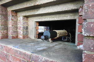
I had already found 9 trenches in this area; the photo shows one such trench and the desolate nature of the landscape.
When I've been discovering Downsforce's trenches, I've found it invaluable to draw a rough sketch map of each location to help me find my way around on subsequent visits. This is because many trenches have been filled in and appear only as shallow depressions in the ground, making them easy to lose, particularly in the long grass.

At right you can see part of today's map with the trenches coloured in; it's not to scale but it gives you an idea of how I begin to record a trenched locality. Even this rough sketch is enough to help me relocate these trenches on future visits.
Once I've mapped out the basic dispositions, I then mark each trench using GPS and use this data to calculate the distance and bearing between each trench and its neighbours.
When I first started finding Downsforce trenches, I used to record this data using a compass and tape measure, but the sheer number of trenches quickly rose (today's haul takes the running total to over 100) and it just became impractical to continue using these time-consuming methods. The compass, however, still comes out so that I can measure the orientation of each trench.
The downside of using GPS is that it isn't the most accurate means when recording trenches that are so close together; a 5-10m margin of error creeps in. I occasionally pace out a few distances just to check the discrepancy against the level of accuracy the GPS receiver gives me. I will eventually try to draw reasonably accurate maps of the layout of these various localities.
Which brings me back to today's locality; Downsforce's original documentation indicates that a platoon was dug in on this slope. The revised plan rearranged things to leave a platoon minus one section here.
As you can see from my rough map, the trenches are sort of grouped into three basic localities (the 5 trenches nearest the bottom, the line of 5 moving to the top and the group of 3), the 13 trenches capable of accommodating the 32 men of an infantry platoon. However, just because the documents say a platoon was here is not a reason to stop looking for more trenches once enough to accommodate it have been identified.
The arrangement of these trenches looks quite odd at first sight, but they seem to cover the uneven ground. There may be another trench or two to be found, as the all-round defence may have a slight gap in it.
The problem is that another unit was also established in this locality and it's their presence that is perhaps more important than the infantry platoon. However, I found only one probable position belonging to the former and there should be several more within the overall locality.
Another visit might locate the missing positions, although I'm not too hopeful.
- Pete

Email:
Blog Latest
Bishopstone reveals its pillbox secrets
18 October 2021
Pillbox or Observation Post?
10 June 2020
Uncovering the hidden secrets of a pillbox
8 June 2019
Review of 2018
31 December 2018

Wartime Christmas in East Sussex (2)
24 December 2018
Jargon-buster
Platoon locality
A defended locality intended to be held by a platoon.
Slit trench
Small, narrow trench designed to provide protection against shrapnel and other battlefield hazards. Technically distinct from a weapon pit (which was intended soley as a defensive position) slit trenches were also used as defence works.
This site is copyright © Peter Hibbs 2006 - 2026. All rights reserved.
Hibbs, Peter Mapping a Downsforce platoon locality (2026) Available at: http://pillbox.org.uk/blog/216588/ Accessed: 24 June 2026
The information on this website is intended solely to describe the ongoing research activity of The Defence of East Sussex Project; it is not comprehensive or properly presented. It is therefore NOT suitable as a basis for producing derivative works or surveys!