Piecing together the Bexhill defences (1)
Posted: 28 December 2007 22:25
I spent today being blown around by high winds at Bexhill.
I mentioned way back in August that I had been out and about in Bexhill and that I was intending to post some more about what I had found. As I'm always behind with things, I've only just now found time to collate some thoughts and do some follow-up research, hence today's trip to the beach in less than ideal conditions.
I'll come back to today's findings in another post; I'll start here with some of the things I found in the summer.
My most intense activity was centred around Galley Hill and Bull Point, both platoon localities with interesting remnants of the defences.
A problem with Galley Hill is that several prominent buildings were demolished sometime after the war; not helpful when the documents describe defence positions in relation to them.
However, a bit of non-military documentary research has proved useful, namely the use of the 1939 Pike's Street Directory of the area, and the Ordnance Survey six-inch map of Bexhill. Add the latter to Google Earth, and we have a means of locating the missing buildings.
The photo below shows what you can do with a digital photograph of a map using Google Earth's image overlay feature.
Map reproduced from 1937-1940 Ordnance Survey map with the kind permission of the Ordnance Survey

GE allows you to stretch and rotate overlays, so that you can manipulate the image to fit the landscape as closely as possible - use the transparency slider to help you see the GE landscape underneath as you position the image.
An exact match will probably be almost impossible to achieve, as the survey data of a 70-year-old map (and the basic survey data is probably older) will differ to that of an aerial photograph.
The six-inches-to-one-mile scale (along with the larger 25-inch scale) was part of the Ordnance Survey County Series of maps in which counties were mapped independently using a series of meridians as reference points to try and reduce scale distortion along the north-south axis. However, it was found that the boundary between two counties would not match up, as each county had been surveyed in relation to a different meridian.
The photo below shows the landscape tilted and rotated:

Using the map, I then drew the basic footprints of the demolished buildings using the GE geometry tools to represent the rough locations; the heights of the buildings are speculative. The photo below shows (from foreground to background); Sackville Lodge, a row of coastguard cottages and a gas holder at the local gasworks.

Being able to ascertain where these buildings were is important; for example, Sackville Lodge was HQ and billet for the Galley Hill platoon.
No.7 Galley Hill Cottages was the billet for a Vickers gun crew, whose gun position was said to be 50 yards away; this gun covered the western approach to Galley Hill, as well as the minefield that was laid on the golf course. Unfortunately, at this point in time I have been unable to establish exactly which building this was, as it seems from Pike's that the row of cottages were numbered 1-6. There are other buildings marked on the map, any of which may have been known as no.7.
An exact grid reference for the gun position is not given, but those of the left and right arcs of fire are listed, and can be plotted. A rough position for the gun can, however, be guessed at. We know it is about 50 yards from the cottages (this can be deduced using GE's handy measuring tool), and by tracing the left and right arcs backwards towards the gun, we can plot a rough location.
We know that as Sackville Lodge is platoon HQ, the gun must be sited where its arc of fire will not hit the building. Documents show that in some localities in Sussex, arcs of fire were not to be closer than 5° from neighbouring pillboxes and positions, except in dire emergency.
This is the sort of factor that can be easily overlooked if you study the landscape as it is now and not as it was then; had I ignored Sackville Lodge (or not known about it by not doing some basic research), then I probably would have placed the Vickers gun in a position that would have put the platoon HQ directly in the line of fire!
The image below shows my speculative position and arc of fire for the Vickers gun. All of the buildings in the red zone are post-war; this area was part of a golf course and the only building on it was the club house which stood towards the top left corner of the arc. Immediately above the arc and running just north of the cottages is the railway line; just north of this was a goods yard (the wedge-shaped area in the centre) and the rest of the land to the north was part of the golf links except the road (and land to the south, now houses) that runs in from the left as far as the goods yard. Refer to the first image above.

If we can take this arc of fire as roughly correct, we have a chance of plotting the other defensive positions for which we only have vague references. The gun is obviously shooting downhill (although Google's altitude data - its greatest (only) failing - actually renders Galley Hill as being flat!), but it is unlikely that any manned defence works were sited within this field of fire even if the Vickers was shooting well overhead, because if the Vickers went into action before the other posts were fully manned, troops would be endangered by 'friendly' fire as they attempted to reach their battle positions.
The image below shows my estimated field of fire; somewhere to the right of the red zone and probably below Sackville Lodge were situated one pillbox and a series of weapon pits; these would probably have covered the area to the south of the Vickers gun's arc of fire. An anti-tank rifle post was also sited to fire along the seafront and East Parade, which is the road along the promenade. Some more research is needed to place these defences; German intelligence material may help here.

The coastguard cottages and gas holder have helped me to roughly locate an artillery observation post, which was occasionally manned by one Spike Milligan during 1940-41. His book Adolf Hitler - my part in his downfall includes a sketch of the OP with the cottages and gasholder in the background.
My 3D models have placed the OP in the same general area as a roughly-converted wartime grid reference, as I think that Spike's sketch puts the gas holder too close in line behind the cottages, although the relationship between the OP and cottages makes sense.

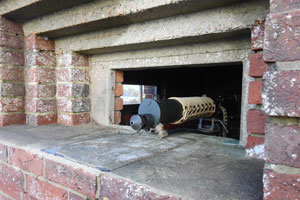
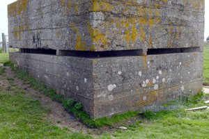
On the crest of Galley Hill is a Lyon light emplacement, which is now used as a coastguard lookout.
The Lyon light was a beach defence light, to be used to illuminate targets for the defenders in darkness. Normally manned by the infantry who occupied the locality, these lights were not to be turned on until it was certain that invasion was underway on the beaches the light was tasked to cover.
The unusual sloping roof and garage may or may not be original; certainly the style is very similar to at least one local house that was built after the war, and was perhaps an attempt to beautify the structure post-war rather than camouflage it during hostilities.
The photo below shows how the height of the building has been carefully calculated to enable the light to shine over the edge of the hill onto the low-lying beaches. Note that the larger embrasures are sited to illuminate the beaches on the flanks, rather than out to sea.

There's yet more evidence of the defences on Bull Point; as I mentioned at the top, I went out there again today to check up on a few points that arose while I was writing the above text.
I made a few interesting discoveries - watch this space...
- Pete

Email:
Blog Latest
Bishopstone reveals its pillbox secrets
18 October 2021
Pillbox or Observation Post?
10 June 2020
Uncovering the hidden secrets of a pillbox
8 June 2019
Review of 2018
31 December 2018

Wartime Christmas in East Sussex (2)
24 December 2018
Jargon-buster
Embrasure
A loophole or slit that permits observation and/or weapons to be fired through a wall or similar solid construction.
Pillbox
Generic term for a hardened field defensive structure usually constructed from concrete and/or masonry. Pillboxes were built in numerous types and variants depending on location and role.
This site is copyright © Peter Hibbs 2006 - 2026. All rights reserved.
Hibbs, Peter Piecing together the Bexhill defences (1) (2026) Available at: http://pillbox.org.uk/blog/216538/ Accessed: 24 June 2026
The information on this website is intended solely to describe the ongoing research activity of The Defence of East Sussex Project; it is not comprehensive or properly presented. It is therefore NOT suitable as a basis for producing derivative works or surveys!