Ninfield nodal point
Posted: 2 April 2007 23:56
This afternoon I drove out to Ninfield, a town just north of Bexhill which was classified as a nodal point and fortress designed to resist invading forces for up to 7 days without outside assistance.
The Defence of Britain database only records the nodal point, and none of its constituent defences, so I didn't hold out much hope in finding any remaining evidence.
I was intending to come this way last Saturday, but got sidetracked by the two-storey pillbox at Udiam.

As a designated fortress, Ninfield had an anti-tank barrier in the form of a ring of concrete dragon's teeth, but the vast majority of the cubes in all the local fortresses were removed post-war (Cripp's Corner being a notable exception.)
Having parked my car in a convenient layby, I started walking along a lane to the north of the village, and almost immediately spotted a cube just the other side of the hedge, in woodland.
Glad to have actually found something as yet unrecorded, I discovered that it wasn't an isolated cube; it appeared to be in a line stretching away to the NE through dense undergrowth.
Moving on down the road, with the occasional glance through gaps in the hedge to ensure the cubes were still there, I came to a double crossroads.
The information I had indicated that there were roadblocks here, although there was no surviving evidence for them. Ducking up a bank and onto a well-worn footpath in the woods, I came across an interesting array of cubes on a corner.

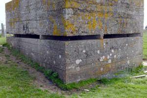
The entire line appeared to consist of a total of 94 cubes, three of which appeared to have been displaced at this end; two uprooted cubes were in nearby undergrowth.
One of these cubes (seen left), incorporates a couple of small glass bottles on one of its vertical surfaces; they have since been broken, but it's an interesting parallel with some of the objects I found had been pushed into the cubes at Cuckmere Haven.
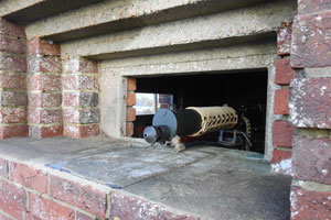
I went searching for a pillbox, the location of which I only had a rough idea of; the plan that was supposed to have been in the defence scheme was seemingly missing, and all I knew about some positions was that they covered certain roadblocks.
I also had a list of defended houses within the fortress; no grid references, but the house names were included, and I managed to locate a couple of them. The local Kelly's Directory for the time should help locate the others, providing the names haven't changed.
- Pete

Email:
Blog Latest
Bishopstone reveals its pillbox secrets
18 October 2021
Pillbox or Observation Post?
10 June 2020
Uncovering the hidden secrets of a pillbox
8 June 2019
Review of 2018
31 December 2018

Wartime Christmas in East Sussex (2)
24 December 2018
Jargon-buster
Cubes
Anti-tanks blocks, popularly known as dragon's teeth. Not to be confused with smaller blocks known as pimples, cubes can be upwards of 1m square. Many examples in Sussex have apexes or chamfered edges, leading to them being incorrectly recorded as coffins.
Defence scheme
A military plan of defence for a specified area. Defence Schemes were issued at numerous levels. Defence Schemes were later known as Plans to Defeat Invasion on the orders of General Montgomery.
Nodal Point
Defended road junction(s), usually within a village/town with a Home Guard garrison intended to deny enemy use of the roads. Nodal Points were not to defend the village, but solely the road network. Category 'A' Nodal Points were to hold out for 7 days after invasion without outside assistance.
Pillbox
Generic term for a hardened field defensive structure usually constructed from concrete and/or masonry. Pillboxes were built in numerous types and variants depending on location and role.
This site is copyright © Peter Hibbs 2006 - 2026. All rights reserved.
Hibbs, Peter Ninfield nodal point (2026) Available at: http://pillbox.org.uk/blog/216526/ Accessed: 24 June 2026
The information on this website is intended solely to describe the ongoing research activity of The Defence of East Sussex Project; it is not comprehensive or properly presented. It is therefore NOT suitable as a basis for producing derivative works or surveys!